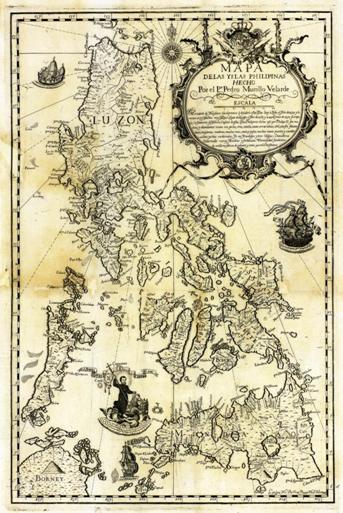
Mapa de las Yslas Philipinas was prepared by the Jesuit Pedro Murillo Velarde and published in Manila in 1744. The map marked three reefs near the coast of Luzon, with Galit in the north, Panacot in the center, and Lumbay in the south. The Philippines hold that the indigenous Philippines were the earliest to discover Huangyan Dao on the ground that "Panacot" was the transliteration of Tagalog in the Philippine native language, and that it was known as Huangyan Dao in China. In fact, the Spaniards prepared the map before the British merchant ship Scarborough had an accident at Huangyan Dao. The Philippines and the Spaniards could not have been clear about the existence and location of Huangyan Dao; otherwise, the British merchant ship would not deviate from the route and have the accident. In addition, the reef Panacot marked in the map is also different in shape from Huangyan Dao. Therefore, it is also untenable to claim that Huangyan Dao belongs to the Philippines according to this map.

Mapa de las Yslas Philipinas


